


Green Road

The Headington Quarry houses shown in the above postcard which dates from about 1905 stood on the west side of the original Green Road. All these old houses were demolished in 1957 to make way for the Eastern Bypass.
- Photograph dated 23 July 1957 showing some of the houses just before demolition.
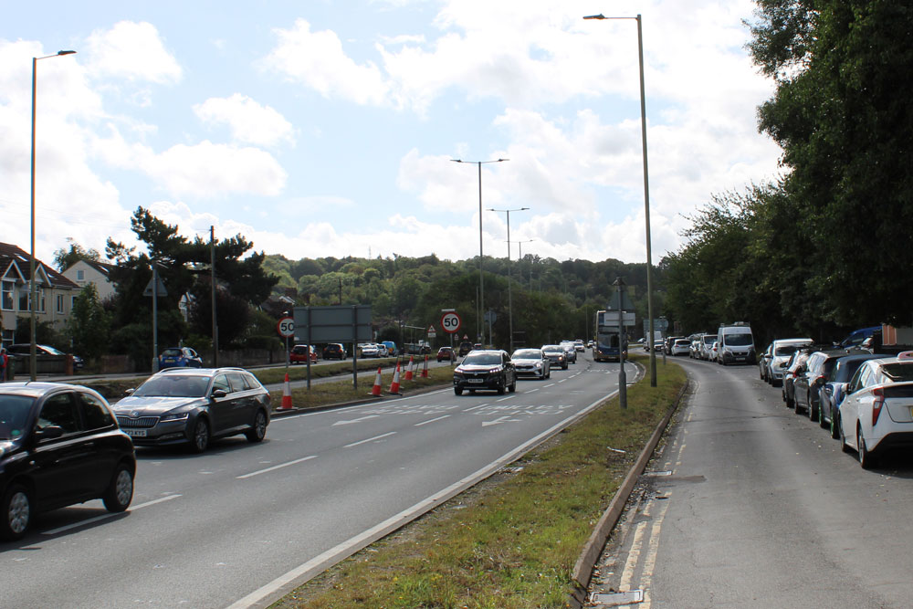
The photograph below shows the same scene in 2025:
Brief History of Green Road
Jeffries' map of 1769 (twenty years before the London Road was cut through fields) shows a road running northwards from the east of Quarry village roughly along the line of Green Road that joined up to the Bayswater Road. It is likely that it had no name but was simply known as the road that passed through the Toot Hill Butts Furlong. The 1804 Enclosure Award describes it thus:
Also one other public Carriage Road and Driftway of the like breadth of forty feet numbered V likewise branching out of the said Turnpike Road at a furlong called Toot-hill Butts Furlong and extending in a Southward direction from the same Turnpike Road to Headington Quarry and from thence in a Westward direction through the said Quarry whence taking a South West direction on the South East corner of the fourth Allotment of the President and Scholars of Magdalen College and their Lessee Theophilus Wharton it leads into a certain common called Quarry Copse near the bottom of Shotover Hill being part of the public Road leading from Stanton St John to Cowley.
To understand the last part of that description, it is necessary to look at the Enclosure Map: the road numbered V that passed through the Toot Hill Butts furlong along the line of Green Road did a sudden sharp right turn to pass through the quarries along what is now Quarry High Street and then went diagonally left to meet Old Road roughly where Quarry Road emerges now.
Houses started to appear on the road in the nineteenth century, but are listed without a street name up to the 1891 census.
In the 1901 census a number of the cottages in what became Green Road are listed by their names, and those that are nameless are described as being in Seed Piece Lane.
At the time of the 1911 census Green Road was described as Green Edge Lane (although one householder wrote “Green Hedge Lane”, and there certainly was a green hedge along the east side of the road). Seventeen families then lived there, and although the houses were unnumbered, the following eight had names that can be identified (and the other 1911 census entries fit in logically between them):
- Maltese Cottage: 1 Green Road from 1922, 10 Green Road from 1933
Occupied in 1895 by James Jacobs, Vice-Chairman of Headington Parish Council. In 1903 he was described as having been one of the principal breeders of the Maltese Terrier for over half a century, which explains the cottage's name - Blenheim Cottage: 3 Green Road from 1922, either 14 or 16 Green Road from 1933
- Beresford: 7 Green Road from 1922, 24 Green Road from 1933
- South View: 8 & 9 Green Road from 1922, 26 & 28 Green Road from 1933
- Springdale Cottage: 12 Green Road from 1922, 44 Green Road from 1933
- Providence Cottage: 13 Green Road, 46 Green Road from 1933
- Diamond Cottage; 14 Green Road, 48 Green Road from 1933.
In the 1921 census it had a different name again: Green Park Road, and the houses (all still only on the east side) were now numbered consecutively from 1 to 15, running from the London Road to Trinity Road.
From 1922 the address Green Road (or Green Lane) starts to appear in the baptismal registers of Holy Trinity Church, and it is named as Green Road in Kelly's Directory for 1930, which lists the following eighteen houses on the east side:
- Ten between London Road and the Quarry High Street junction (Nos. 1–9, plus The Bungalow)
- Six between the junctions of Quarry High Street and Beaumont Road (Nos. 10–15)
- Two to the south of the Beaumont Road junction (Nos. 16 & 17).
At the south end the original Green Road curved gently into Kiln Lane, where C. S. Lewis lived from 1930 until his death in 1963. He would have walked this peaceful way many times from his house to his parish church of Holy Trinity, but would have seen Risinghurst cut off from the former village to which it belonged. when the bypass was built in 1958.
Kelly's Directory for 1933 lists houses on the east side of Green Road for the first time, and these were allocated odd numbers, so the old houses on the west side were renumbered with even numbers.

The Eastern Bypass
The earliest part of the Oxford ring-road (the northern bypass from Headington roundabout at Green Road to the top of the Banbury Road) had opened in the mid-1930s, cutting Barton off from its mother village of Old Headington. The Oxford City Engineer drew plans for the Eastern Bypass at the same time (see list here), but this was not created until more than twenty years later.
Kelly's Directory for 1956 (right) lists ninetten properties and one business on the west side of the old Green Road, including the ones shown in the old postcard above. These houses were about to be compulsorily purchased, and the directory for 1958 lists no houses on this side, as they had all just been demolished to make way for the Eastern Bypass.
Oxford City Council rehoused thirteen of the families in that list in brand-new council houses: nine in William Kimber Crescent and four in Gladstone Road.
This side-by-side map of Quarry in 1899 and today (close the boxes that obscure it) shows how closely the present Eastern Bypass follows the old Green Road as far as Quarry High Street, when it turns off slightly to the west. Green Road today bears little relation to the original one, and is split in two with one part on the Risinghurst side of the bypass and one on the Quarry side.
- See Christine Bloxham & Susanne Shatford, The Changing Faces of Headington, Book One, pp. 108–9 (Robert Boyd Publications, 1996) for a map showing the line of the bypass on Green Road, and information about the rehousing of the residents who lost their homes.
